Where in the World are We?

To see where in the world we've been:

Saturday, August 23, 2014

Montagne des Francais, Antisiranana

We took a day trip from Antisiranana (about a half hour ride) to Montagne des Francais in order to see the spectacular views of the bay and the Sugarloaf island.  Our guide book recommended we also see the 1000 Boabab Park, so we did that, too.  It was not worth it.  I think in the 8 years since our book was published nothing has been done to the park.  Most of the baby Boababs are dead of buried in brush, the paths were nearly impassable, and the suspension bridge was out of order.  But the guide still charged full price for the half hour "tour". 

The hike up the mountain, on the other hand, was amazing.  We climbed the mountain without a guide, which you're probably supposed to have, but we did fine without one, as the paths were well maintained and we could see the bay at all times so it was hard to get lost.  And, we could not find an open tourist center anywhere anyway.  The hike up the mountain and back took about 5 hours, and it was well worth the climb.  Caryl turned over a rock and found a cockroach and a scorpion - what a lovely pair!  At the top of the mountain are the remains on Fort Anosiravo, an old French structure.  The French had also bored holes in the mountain for easier access - we took advantage of these during our climb.

Thursday, August 21, 2014

Amber Mountain National Park, Joffreville, Madagascar

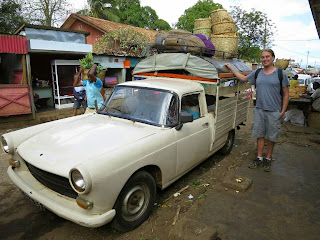
Our adventure to Amber Mountain and Joffreville started when we informed our hotel hostess of our plans, and her reaction was, "Joffreville?  Why do you want to go to Joffreville?  It is cold there!  Lots of rain!"  With this farewell, we pressed on.  We got to the taxi bus stand, and waited for a while for it to fill up, see picture of Caryl next to a converted pick up truck.  At peak capacity, there were 25 people inside, which I state loosely, since about four of them were hanging off the back.  The road to Joffreville, the closest town to Amber Mountain National Park, was actually pretty good; it took us about an hour or so to get there (about 30km).  We arrived, as usual, without a place to stay for the night.  So, Caryl left me with our bags at an abandoned French building to look for a hotel (see picture).  We finally settled on Relais de Amber Mountain Bunalows (at least that's what we think the name is, no signs).  The rooms were pretty nice and the garden in the back was amazing, though the water situation was unacceptable.  While they say there was " running water," when we turned it on, decaying plant matter and mosquito larva came out of the shower head.  We only spent one night there. 

After getting settled in, we went to the hotel restaurant for lunch. Caryl quickly made a friend; there was a roaming tortoise in the restaurant. Caryl decided to name her Shelly. As you can see in the pictures there is rice around the turtle's mouth, which Caryl had fed her.  He still talks about Shelly to this day (four days later). 

We then decided to walk the 3 kilometers to the park entrance to figure out what hikes we could do in the coming days. Unfortunately, we did not realize the path was up hill and in the sun the whole way, which was mildly uncomfortable. After getting to the park office we learned that most of the hiking trails were closed due to the activity of bands of thieves and robbers who had robbed a couple of tourists at gun point last year.  So now most of the hikes and all the ones to Amber Mountain are closed. There were only 2 hikes remaining, a short one lasting about 3 hours and a longer one about 4 hours. We decided to do the shorter hike the same day since it was still pretty early in the day.  So we hired a guide, Garry, and started the journey.

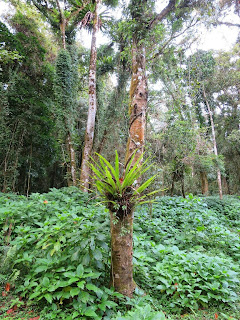
Amber Mountain park is much different than Ankarana, mainly because of the climate. Amber Mountain is much colder and rainier, and the forest is full of rivers. We saw lots of interesting wildlife such as the second smallest color changing chameleon in the world and more leaf-tailed geckos.

Since we were unable to do any more of the hikes we wanted to do without hiring armed guards, we decided to pack up and come back to Ansiranana the following morning.

Antisiranana, Madagascar

Since coming here, we have learned a great deal about Madagascar's involvement during WWII.  Apparently, in 1942, British troops invaded Antisiranana, then known as Diego Suarez.  At that time Diego was controlled by the French, who were in turn occupied by Nazi Germany. So, during the Battle of Madagascar, in May of 1942, the British forces attacked and conquered the town and port of Diego Suarez.  They were especially worried about Japanese troops taking over the island, as during that time the Japanese had the longest range submarines and could have disrupted important trade and communication routes. 

Currently, there are two war cemeteries in the downtown Antisiranana area, one for the British soldiers and one for the French, though there are French cemeteries all over northern Madagascar. 

The first cemetery we went to see was the British one, maintained by the Commonwealth War Graves Commission (more on them in a bit).  There is a small memorial area and plaque informing visitors about the Battle of Madagascar and the cemetery.  Caryl and I signed their guest book - it looks like no one had visited in a few months.  I will write out the part from the plaque about the buried soldiers, because I found it very interesting: "Diego Suarez War Cemetery.  The graves of the casualties of the campaign, and of the garrison in its aftermath, were gathered into this cemetery.  They number 315 (Navy 9, Army 290, Air Force 15, Merchant Navy 1) and by Forces comprise 166 British, 1 Australian, 10 South African, 132 East African, 5 Mauritian and 1 Belgian.  The soldiers whose graves are unknown are commemorated on the East Africa Memorial in Nairobi War Cemetery, Kenya; sailors on memorials at their home ports; and airmen on the Airmen memorial in Egypt."

I also read a bit about the Commonwealth War Graves Commission; I had never heard of this.  Apparently the Commission is made up of 6 member states: United Kingdom, Canada, Australia, New Zealand, India and South Africa.  From Wikipedia:  "The Commission, as part of its mandate, is responsible for commemorating all Commonwealth war dead individually and equally. To this end, the war dead are commemorated by name on a headstone, at an identified site of a burial, or on a memorial. War dead are commemorated uniformly and equally, irrespective of military or civil rank, race or creed.  The Commission is currently responsible for the continued commemoration of 1.7 million deceased Commonwealth military service members in 153 countries."

The experience of walking through this immaculately manicured plot of land, maintained by 6 countries, looking at the names of the fallen soldiers, was surreal.  Reading their ages - most under 25, fathers, husbands, sons.  There were 3 gardeners on duty.  Just outside the cemetery gates young children, maybe 9 or 10, were playing, chasing each other around on the dirt road amongst rubbish and discarded plastic bags.  Leaving the cemetery I wondered if I were one of those soldiers, if that is how I would want to be remembered.  While the cemetery looks beautiful, few visit it, and it feels like such a waste of resources in a country so in need.  While I know this could never happen, I wonder if turning the cemetery into a proper playground for the kids wouldn't be a better use of the Commission's resources?  While maybe a bit morbid, couldn't we have a Memorial park and garden for the future generation?  Commemorate the dead, but also focus on the living?  Or maybe not have wars in the first place, and save our energy for the many problems we need to work on that don't include race or religion?  Just a thought.

The French cemetery is right next to the local cemetery, and is very different.  For example, goats and zebu graze amongst the graves, unaware and blissfully ignorant of the symbolism of the stones they pee on (seriously, I watched a goat pee on a French grave).

Antisiranana, aka Diego Suarez

After waiting for about an hour and a half for a taxi bus with open seats to drive through Mahamasina, we eventually made it to Antisiranana, 105km north.  Took about 3 hours.  The bus we flagged down had been in transit for about 22 hours, going from Antananarivo, the capital, to Antisiranana.  Everyone looked tired and cranky, but happy to be finishing up the drive.  We met a nice Jehova's Witness who spoke pretty good English; she was traveling to a small village just outside of Antisiranana, where her husband was waiting for her. 

Antisiranana is the sixth largest city in Madagascar, with approximately 75,000 inhabitants.  It is a pleasant, slow-moving city on the bay with a few more western comforts than Hell-ville.  Though I was still unable to find dental floss or antibacterial gel anywhere.

Caryl found us an amazing hotel named Le Jardin Exotique, complete with a beautiful garden with ocean view, lemurs, and even a turtle.  The staff is also amazingly friendly. 

Pictures:
1. Downtown Antisiranana.
2. Lemurs at our hotel.
3. Abandoned French building - Madagascar was a French colony until 1960.
4. & 5. Cute park at the northern edge of town.
6. Lighthouse.
7. Statue of Joffre, a French General during WWI.
8. Antisiranana Chamber of Commerce.